|
| Natural
Parks & Mining | Zamora |
| Podocarpus National Park | Palphinia
|
| Chicaña River | Natentza
Farm | Viewpoints |
| Traditions | Cuisine
| Map of Zamora Chinchipe, Ecuador |
Natural Parks and Gold
Mining
Zamora-Chinchipe, in southeastern Ecuador, is home to a variety of reserves
such as Podocarpus National Park. The geography here is extremely varied
due to the influence of the Eastern and Condor highland areas. The area’s
climate is wet tropical and its average temperature is 18 degrees centigrade.
Zamora
Situated at the confluence of the Zamora and Bombuscara rivers, Zamora is
a growing provincial capital. The province as a whole is rich in natural
beauty and has a wealth of plant and animal species - tapirs, capibaras,
guatusas, pumas, birds, and insects – as does the city of Zamora. The
area is also the country’s mining capital, with gold mines in Nambija,
Chinapinza, and Guayzimi.
TOP
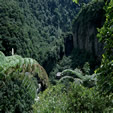
Podocarpus National Park
This cloud forest, stretching west to east from the city of Loja to Zamora,
has many rivers and various species of bird in its 146,200 hectares. Elevations
in the park vary from 1,000 to 3,000 meters with temperatures varying from
8 to 20 degrees centigrade. The Park also has more than 100 lakes and an
uncountable number of waterfalls and canyons and a myriad of plants and
mammals. The Park was originally established in order to protect the Podocarpus
populations that thrive within its borders.
TOP
Palphinia
Located just 5 km from Zamora, this greenhouse has many species of orchids.
TOP
Beaches of the Chicaña River
Chicaña farm, which breeds sheep and pigs, has lovely natural beaches.
It’s located 55km from Zamora.
TOP
Natentza Farm
You can fish in the Nangaritza River from this cattle ranch, located 70
km from the provincial capital. Equipment can be rented on site.
TOP
Viewpoints
There are three interesting lookout points in the province - Araunjo (on
the Puyo-Macas road), Mera (Puyo-Baños road), and Puyopungo (Macas
road).
TOP
Traditions
Shigras(bags), hammocks, seed necklaces, chonta decorations, and
spears are just a few of the area's locally produced, handcrafted artisan
wares.
TOP
Cuisine
As in Pastaza, fish and palm heart maytos, guanta, guatusa
and danta stew, sancocho, empanadas, yucca bread, and
humitas are the most typical dishes of this region. Chicha
made from yucca or banana is also popular as is Shuar chicha.
TOP
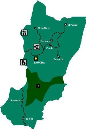
 Map of Zamora Chinchipe, Ecuador
 |
|
|
 |
Province's Capital |
 |
Road |
 |
Cities |
 |
Fishing |
 |
Handicrafts |
 |
Ethnic Group |
 |
Podocarpus |
|
TOP
| Natural Parks & Mining
| Zamora |
| Podocarpus National Park | Palphinia
|
| Chicaña River | Natentza
Farm | Viewpoints |
| Traditions | Cuisine
| Map of Zamora Chinchipe, Ecuador |
|